Archive:Coastal region statistics
This Statistics Explained article is outdated and has been archived - for recent articles on Coastal regions see here.
- Data from February 2012. Most recent data: Further Eurostat information, Main tables and Database.
Maps can be explored interactively using the Eurostat Statistical Atlas (see User's manual).
This article depicts two key issues for coastal regions in the European Union (EU), maritime transport and tourism; note that an article on tourism presents a more general analysis of regional tourism statistics, while an article on regional transport statistics provides an analysis for other transport modes. The present article emphasises the characteristics of coastal regions, taking into account the Member State to which they belong and the maritime basins they border.

(million tonnes) - Source: Eurostat (mar_go_aa)
(% share of total, in terms of gross weight) - Source: Eurostat (mar_go_aa)


(million tonnes) - Source: Eurostat (mar_go_aa)
(million tonnes) - Source: Eurostat (mar_go_aa)

(1 000 persons) - Source: Eurostat (mar_pa_aa)
(% share of total) - Source: Eurostat (mar_pa_aa)

(1 000 persons) - Source: Eurostat (mar_pa_aa)
(1 000 persons) - Source: Eurostat (mar_pa_aa)
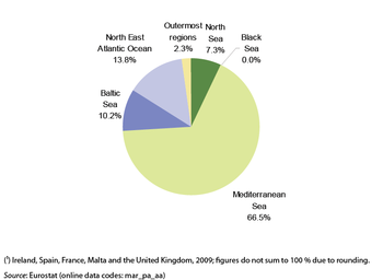
(% share of total) - Source: Eurostat (mar_pa_aa)

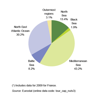
(% share of total) - Source: Eurostat (tour_cap_nuts3)
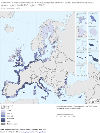
(bed places per km²) - Source: Eurostat (tour_cap_nuts3) and (demo_r_d3area)
Main statistical findings
EU coastal regions and their maritime basins
Coastal regions are statistical regions defined at NUTS level 3 with a coastline or with more than half of their population living less than 50 km from the sea (for more information see the definitions in Data sources and availability). As Map 1 shows, EU coastal regions border several main maritime basins: the Baltic Sea, the North Sea, the North-East Atlantic Ocean, the Mediterranean Sea, the Black Sea and outermost regions. Naturally, these regions are generally distributed along oceans and seas bordering the EU coastline: an important characteristic of the outermost coastal regions, which include the island regions of Canarias (Spain), Madeira and the Açores (both Portugal) in the Atlantic Ocean as well as the French overseas territories of Guadeloupe, Martinique, Guyane and Réunion, is their distance from the European mainland.
EU coastal regions are located in 22 of the Member States that have a coastline; the Czech Republic, Luxembourg, Hungary, Austria and Slovakia are landlocked countries and are not presented in this analysis. There is currently no agreed typology for non-member countries, so the analysis does not include any statistics on EFTA or candidate countries either.
All NUTS level 3 regions within the island Member States of Cyprus (one region) and Malta (two regions) are coastal regions, as are all the regions in Denmark (11 regions); in Estonia and Ireland all regions except one are coastal regions.
Seven of the 22 Member States with a coastline have coastal regions in more than one maritime basin. These include not only France, Spain and Portugal with outermost coastal regions, but also: Spain and France, which have regions on the coasts of the North-East Atlantic Ocean and the Mediterranean Sea; Denmark, Germany and Sweden, which have regions on the coasts of the North Sea and the Baltic Sea; and the United Kingdom, which has regions on the coasts of the North-East Atlantic Ocean and the North Sea.
Maritime freight transport
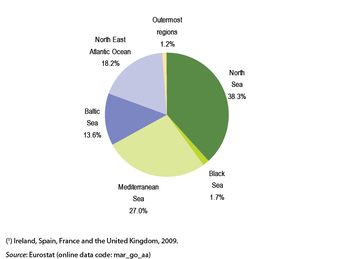
The total quantity of freight handled in EU ports in 2010 was 3 641 million tonnes, indicating the important role maritime freight transport plays, particularly in extra-EU trade. The geographical spread of the main seaports within the EU (see Map 2) illustrates the spread of maritime freight transport, allowing large volumes of goods to be loaded and unloaded close to their main recipients and producers. Figure 1 provides a summary of the distribution of maritime freight by basin, clearly showing the dominance of ports in North Sea regions, and the relatively low share of freight handled in ports in regions along the Black Sea or in the outermost regions.
The region of Groot-Rijnmond in the Netherlands, with the port of Rotterdam, handled by far the largest quantity of maritime freight; 405 million tonnes in 2010, more than two and a half times the quantity of the second-ranked region, Antwerpen in Belgium (160 million tonnes), and nearly four times the quantity of freight that was handled in the German region of Hamburg (105 million tonnes); all three of these regions were on the North Sea. Six other coastal regions recorded maritime freight in excess of 50 million tonnes, including the French regions of Seine-Maritime (including the ports of Le Havre and Rouen) which handled the largest quantity of maritime freight on the North-East Atlantic coast and Bouches-du-Rhône (Marseille) which handled the largest quantity of maritime freight on the Mediterranean coast. For the other basins the largest quantities of maritime freight handled in EU coastal regions were: 39 million tonnes in Trojmiejski (Poland, including Gdansk and Gdynia) on the Baltic coast, 35 million tonnes in Constanta (Romania) on the Black Sea and 16 million tonnes in Gran Canaria (Spain) among the outermost regions.
Table 1 shows which coastal region at NUTS level 3 and which port handled the largest amount of maritime freight in 2010 for the coastal Member States. In most Member States the coastal region with the most maritime freight contained the largest freight port, but this was not the case in Greece, France or Italy: Agii Theodori was the largest freight port in Greece and is located in the region of Korinthia; Marseille was the largest freight port in France (in the region of the Bouches-du-Rhône); and Genova was the largest freight port in Italy (in the region of the same name). Table 1 also provides an overview of the quantity of freight handled and recent developments for each of the EU’s coastal Member States. The three Member States with the largest quantity of maritime freight in 2010 were the Netherlands, the United Kingdom and Italy, followed at some distance by Spain and France. Between 2007 and 2010 the quantity of maritime freight handled within the EU-27 fell by 7.5 %, illustrating the impact of the financial and economic crisis. For most of the Member States shown in Table 1 the rate of change is shown between 2007 and 2010, and therefore reflects the beginnings of the recovery after the crisis. Nevertheless, Lithuania, Malta, Poland, the Netherlands and Estonia were the only Member States to record higher levels of maritime freight in 2010 than in 2007, while Greece, Romania and Denmark reported maritime freight transport was at least 20 % lower in 2010 than three years earlier (a similar decline was recorded in Ireland from 2007 to 2009).
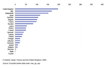
Figures 2 and 3 provide an analysis of maritime trade in each Member State’s coastal regions, separating inward and outward freight transport. The important role of the Netherlands as a point of entry into the EU for maritime trade can be seen clearly, as it ranked first in terms of inward maritime freight transport, but third in terms of outward transport; the reverse situation was observed for the United Kingdom. Among the smaller Member States the position of Latvia was remarkable, having the ninth largest outward maritime transport of freight whereas it ranked in position 21 for inward transport. There were also relatively large differences in the rankings between inward and outward maritime freight transport for Ireland and Estonia. In the vast majority of Member States, the quantity of inward maritime freight transport handled in its coastal regions exceeded the quantity of freight moving in the opposite direction: only in the Baltic Member States, Poland and Romania were the quantities of outward maritime freight transport greater than inward maritime freight.
Maritime passenger transport
The total number of maritime passengers in or out of EU-27 ports in 2010 was 395.6 million. The number of passengers embarking or disembarking in EU ports fell relatively strongly in 2009 (-2.2 %) and 2010 (-2.0 %) following on from a smaller fall (-0.3 %) in 2008.
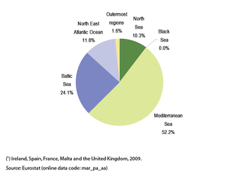
Figure 4 summarises the distribution of maritime passengers, based on sea basins, and can be contrasted with Figure 1 which provided a similar analysis for maritime freight transport. The Mediterranean Sea basin dominated maritime passenger transport, accounting for more than half (52.2 %) of all passengers along the EU’s coast. The next largest share was for the Baltic Sea, followed by the North-East Atlantic Ocean and then the North Sea — the latter therefore had a substantially lower share of maritime passenger transport than maritime freight transport. There is practically no maritime passenger transport in the EU coastal regions of the Black Sea: neither of the NUTS level 3 regions in Romania reported any passenger transport, while only one of the Bulgarian regions (Varna) reported a minimum number of passengers (1 000).
By far the largest number of passengers transported by sea in 2010 was recorded by the Attiki region of Greece (43.8 million), where the port of Piraeus is the main gateway for passengers to the Greek islands. The second highest number of passengers was recorded in Napoli with 23.4 million. Six more regions recorded more than 10 million maritime passengers in 2010 including Kent (13.4 million, 2009) and Pas-de-Calais (10.5 million, 2009) reflecting services across the English Channel principally between the ports of Dover on the English side and Calais on the French side. The other regions over 10 million passengers were: Messina (Sicily, Italy) which services several ferry connections to the mainland of Italy as well as ferry routes to Malta and Tunisia; the Swedish regions of Skåne län and Stockholms län, servicing a large number of ferry connections to the other countries around the Baltic Sea; the Danish region of Vest- og Sydsjælland, with ferry connections to other parts of Denmark and to neighbouring Germany.
Figure 5 provides an analysis of the regional dispersion of maritime passenger transport for all of the EU coastal Member States. Maritime passenger transport tends to be concentrated in particular coastal regions within each Member State. Among the Member States with significant maritime passenger transport in multiple coastal regions, at least one coastal region had no significant maritime passenger transport and the coastal region with the highest level of maritime passenger transport normally had a value that was at least double the national average. The most notable levels of concentration in individual regions were in the United Kingdom, Greece, Italy and France, where the number of passengers in the region with the highest level of maritime passenger transport was at least 10 times above the national average for all coastal regions. The one Member State that was an exception to these two general observations was Malta, where maritime passenger transport is dominated by the domestic service between its two regions, the islands of Malta and Gozo, and which therefore have very similar numbers of maritime passengers. Note that Cyprus and Lithuania have only one coastal region, Slovenia has three regions meeting the criteria as a coastal region but only one actually has a coastline, while Romania and Bulgaria have very low levels of maritime passenger transport and so no regional concentration can be observed.
Cruise passengers
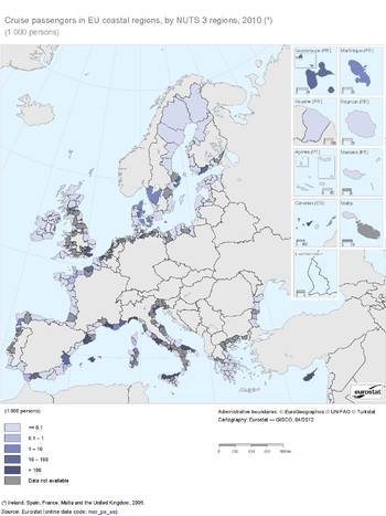
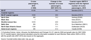
Cruise passengers accounted for around 2 % to 3 % of all maritime passengers in the EU-27. The total number of passengers starting or ending a cruise in EU-27 ports in 2009 was in excess of 10.5 million, and this figure was nearly 40 % above the level in 2007. Early estimates suggest that the number of cruise passengers in the EU-27 fell by around 7 % between 2009 and 2010.
Figure 6 summarises the distribution of cruise passengers, based on sea basins, and can be contrasted with Figure 4, which provided a similar analysis for all maritime passenger transport. The dominance of the Mediterranean Sea basin, which was apparent for all maritime passenger transport, was even greater when restricted to cruise passengers, accounting for approximately two thirds (66.5 %) of all cruise passengers in the EU. The North-East Atlantic Ocean also had a larger share of cruise passengers (13.8 % compared with 11.8 % for all maritime passengers), as did the outermost regions (2.3 % compared with 1.6 % for all maritime passengers). The share of the Baltic Sea was just 10.2 % for cruise passengers, less than half its share of all maritime passengers.
The largest number of cruise passengers was reported for the coastal region of Barcelona, with 1.3 million passengers in 2009. While Barcelona was the only NUTS level 3 coastal region in the EU-27 where the number of cruise passengers exceeded 1 million, there were six other regions with more than half a million passengers, four of them in Italy (Venezia, Savona, Genova and Napoli) and one in Spain (Mallorca), while Southampton (classified to the North-East Atlantic Ocean) in the United Kingdom was the only region with more than half a million cruise passengers that was not on the Mediterranean coast. The next largest cruise passenger numbers were in the Danish capital city region of Byen København and the German region of Kiel (Kreisfreie Stadt), both classified to the Baltic Sea region and having just over 300 000 cruise passengers each in 2010. Hamburg (Germany) completed the top 10 and had the largest number of cruise passengers (216 000) of any coastal region on the North Sea. The largest number of cruise passengers among the outermost coastal regions was 122 000 in Tenerife (Spain). Varna in Bulgaria was the only Black Sea region in the EU to record any cruise passengers (1 000 in 2010).
Tourism in coastal regions
In the EU-27 as a whole there were around 28.1 million bed places in hotels, campsites and other collective tourist accommodation in 2009, of which nearly three fifths were in coastal regions. Table 3 shows the availability of tourist accommodation in the coastal regions of each of the Member States, while Figure 7 summarises this across the various sea basins. EU coastal regions around the Mediterranean Sea offered 7.1 million bed places in 2010, some 43.2 % of the total among all coastal regions in the EU-27. The second largest amount of tourist accommodation available was along the coast of the North-East Atlantic Ocean, with 4.9 million bed places. At a national level, the coastal regions of France, Italy, the United Kingdom and Spain had by far the greatest number of bed places available for tourist accommodation, collectively accounting for 71.9 % of the total in EU coastal regions. The type of accommodation offered varied greatly between Member States, with the proportion of bed places in hotels over 80 % in Latvia, Ireland, Greece, Bulgaria, Cyprus and Malta, but below 25 % in the Netherlands, Poland, Denmark and France (where campsites and other collective tourist accommodation dominated).
The single largest number of bed places available in any coastal region in the EU in 2010 was 364 500 in Venezia (Italy), followed by Mallorca and Girona (Spain), Var and Vendée (France), and Cornwall and the Isles of Scilly (United Kingdom), all with more than 250 000 bed places in tourist accommodation. In total, there were 36 coastal regions in the EU-27 that had more than 100 000 bed places available for tourist accommodation, of which 12 were in France, eight in Spain, six in the United Kingdom, five in Italy, and one each in Bulgaria, Greece, Portugal, Romania and Sweden.
The density of tourist accommodation can be measured in terms of the number of bed places per square kilometre (km²). As well as climatic conditions attracting tourists, visits to coastal regions may also be on account of the attraction of the coast itself, or for cultural or professional reasons. While a lower density of tourism capacity in a region may reflect a relatively less developed tourism infrastructure, it may also simply result from a region having a vast area relative to the length of its coastline which consequently reduces the density — this explains in part the relatively low tourism density in some regions along the coast of the Baltic Sea, for example, in several Finnish and Swedish regions. As Map 5 shows, the density of tourism capacity was high in several regions around the coast of England, peaking at close to 2 000 bed places per km² in the region of Blackpool on the coast of the North-East Atlantic Ocean. Several NUTS level 3 regions in or around capital cities were among the coastal regions with highest densities of tourist accommodation, including capital city regions in the United Kingdom, Denmark, Malta and the Netherlands. Around the Mediterranean coast the Italian region of Rimini had the highest density of tourist accommodation, 329 bed places per km², followed by Venezia and Malta.
Data sources and availability
Coastal regions
A coastal region of the EU is a statistical region defined at NUTS level 3 of the geographical classification that has a coastline or more than half of its population living less than 50 km from the sea. The EU-27 has 446 such regions, belonging to the 22 Member States which have a coastline. Of these 446 coastal regions, 372 have a coastline, while 73 meet the second criterion. Lastly, given the strong influence of the sea, the German region of Hamburg has been added to the list.
The 22 Member States which have a coastline are: Belgium, Bulgaria, Denmark, Germany, Estonia, Ireland, Greece, Spain, France, Italy, Cyprus, Latvia, Lithuania, Malta, the Netherlands, Poland, Portugal, Romania, Slovenia, Finland, Sweden and the United Kingdom.
Maritime transport
Eurostat’s regional transport statistics show passenger and freight movements measured in terms of passengers and tonnes. Freight statistics are divided into tonnes of freight loaded and unloaded. Passenger data are divided into passengers embarking and disembarking.
Currently, data on maritime transport are collected under Directive 2009/42/EC on statistical returns in respect of carriage of goods and passengers by sea. This directive provides detailed quarterly data for ports handling more than one million tonnes of goods or recording more than 200 000 passenger movements a year. The data collected at port level are then aggregated to NUTS regions.
Tourism
A system of tourism statistics was established in Council Directive 95/57/EC of 23 November 1995 on *the collection of statistical information in the field of tourism. This was amended in 2004 and 2006 and again in July 2011 (although these latest changes will only enter into force for data for the 2012 reference year). More information relating to the data collection exercise is provided in the article on tourism.
Tourism statistics in the EU consist of two main components: statistics relating to capacity and occupancy in tourist accommodation, and statistics relating to tourism demand: this article presents data on tourism supply and focuses on data for coastal regions. In most Member States, tourism supply data are collected via surveys filled in by accommodation establishments.
Context
The EU and EFTA countries have an enormous coastline along the Atlantic and Arctic Oceans and several sea basins: the Baltic Sea, the North Sea, the Mediterranean Sea and the Black Sea. The Atlantic Ocean coastal regions border the Celtic seas on one hand and the Bay of Biscay and the Iberian coast on the other. None of the EU Member States have a coastal region classified to the Arctic Ocean basin. The European Commission’s Directorate-General for Maritime Affairs and Fisheries provides more information about each of these sea basins in the European Atlas of the Seas, as well as information about strategies for each area.
Fishing, shipbuilding, maritime transport, ports and offshore energy-related activities (such as the extraction of fossil fuels and electricity generation) are major coastal and maritime economic activities; furthermore, tourism plays an important role in many coastal economies, while the oceans and seas have important recreational, cultural and ecological functions.
Maritime and coastal policies
Competition for marine space and the cumulative impact of human activities on marine ecosystems require a collaborative and integrated approach to the wide range of policy areas affecting maritime issues. In October 2007, the Commission adopted the Blue Paper launching ‘An integrated maritime policy for the European Union’ (COM(2007) 574 final). The aims of this policy are to maximise the sustainable use of oceans and seas, enhance Europe’s knowledge and innovation potential in maritime affairs, ensure development and sustainable growth in coastal regions, strengthen Europe’s maritime leadership and raise the profile of maritime Europe. This policy stresses the importance of coastal regions due to their geographic location and aims to develop sea basin strategies.
The marine strategy framework Directive was adopted in 2008 within the overall context of the integrated maritime policy and aims to protect the marine environment and natural resources and create a framework for the sustainable use of marine waters.
Recommendation 2002/413/EC of the European Parliament and of the Council concerning the implementation of integrated coastal zone management in Europe defines the principles of sound coastal planning and management and dates from 2002; in other words before the integrated maritime policy. The recommendation was established in response to the perception that coastal planning activities or development decisions were often taken in a sectoral, fragmented way, leading to inefficient use of resources, conflicting claims on space and missed opportunities for more sustainable coastal development. Given the need for coherent planning of coastal and maritime areas, a proposal for a follow-up to the 2002 recommendation is, at the time of writing, being prepared.
Maritime transport and ports
Maritime transport provides the main mode for EU imports and exports to the rest of the world: around two fifths of the EU’s external freight trade is seaborne; short sea shipping also plays a significant role in intra-EU trade. The quality of life on islands and in peripheral maritime regions depends on maritime transport services.
The EU’s maritime transport policies aim to prevent substandard shipping, reducing the risk of serious maritime accidents and minimising the environmental impact of maritime transport. EU legislation also concerns working conditions within the maritime transport sector and the protection of consumers’ rights.
In 2009, the European Commission updated its ‘Strategic goals and recommendations for the EU’s maritime transport policy until 2018’ (COM(2009) 8). The two main recommendations concerned:
- the ability of the maritime transport sector to provide cost-efficient maritime transport services adapted to the needs of sustainable economic growth of the EU and world economies;
- the long-term competitiveness of the EU shipping sector, enhancing its capacity to generate value and employment in the EU, both directly and indirectly, through the whole cluster of maritime industries.
In October 2007, the European Commission adopted a ‘Communication on a European ports policy’ (COM(2007) 616), focussing on capacity, freedom of access, competition, flexible employment and the environment. It aims to help concentrate efforts so that the EU’s ports can face future challenges, attract new investment and fully contribute to the development of intermodal transport.
Coastal tourism
Tourism in coastal regions can provide employment opportunities and also contribute to regional development and economic and social integration. In its 2010 communication on tourism (see the article on regional tourism statistics for more information) the European Commission recognised the importance of maritime and coastal tourism as a catalyst for economic development and indicated its intention to carry out actions to encourage tourism development as part of an integrated maritime policy.
See also
Further Eurostat information
Data visualisation
- Regional Statistics Illustrated - select statistical domain 'Tourism' (top right)
- Regional Statistics Illustrated - select statistical domain 'Transport' (top right)
Publications
- Eurostat regional yearbook 2011 - Chapter 13 - Coastal regions
- Eurostat regional yearbook 2012: Focus on coastal regions
- Nearly half of the population of EU countries with a sea border is located in coastal regions - Statistics in Focus 47/2009
- Portrait of EU coastal regions - Statistics in focus 38/2010
- The Mediterranean and Black Sea basins - Statistics in Focus 14/2011
Database
- Regional tourism statistics (reg_tour)
- Occupancy in collective accommodation establishments: domestic and inbound tourism (reg_tour_occ)
- Capacity of collective tourist accommodation: establishments, bedrooms and bedplaces (reg_tour_cap)
- Regional transport statistics (reg_tran)
- Other regional transport statistics (reg_otran)
- Maritime transport of passengers by NUTS 2 regions (tran_r_mapa_nm)
- Maritime transport of freight by NUTS 2 regions (tran_r_mago_nm)
- Maritime transport of passengers by NUTS 2 regions (questionnaire) (tran_r_mapa_om)
- Maritime transport of freight by NUTS 2 regions (questionnaire) (tran_r_mago_om)
- Other regional transport statistics (reg_otran)
