Archive:Agriculture - landscape features
This article is outdated and has been archived. For recent articles on Agriculture, see here.
- Data from September 2013. Most recent data: Further Eurostat information, Main tables and Database.
This article presents statistics on landscape features in the European Union (EU).
(% of all agricultural holdings) - Source: Eurostat (ef_pmlandscape)
(% share of the total number of holdings) - Source: Eurostat (ef_pmlandscape)

(% share of the total number of holdings) - Source: Eurostat (ef_pmlandscape)
(% of all agricultural holdings) - Source: Eurostat (ef_pmlandscape)
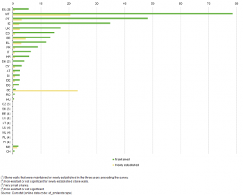
(% of all agricultural holdings) - Source: Eurostat (ef_pmlandscape)
Main statistical findings
Many of the landscape features associated with agriculture, such as hedges, stone walls, tree lines, ditches and other watercourses, are the result of historical farming practices and human endeavour. In many countries, the open field system of farming on land that was typical centuries ago was replaced by a system of enclosures. This reorganisation of land resulted in visible demarcation barriers — often using the natural resources available locally — denoting areas belonging to private landowners and other local boundaries, as well as practical barriers for keeping livestock under control). In a number of other countries, landscape features were used or built to increase cultivated land areas (such as walls for terraces) and as a barrier to prevent grazing in specific areas (such as in olive groves or vineyards). The choice of feature was often a function of the climatic conditions (hedges being very difficult to grow in dry conditions and ditches being useful to drain rain soaked fields) and geology (rocks and stones being prevalent in some landscapes but not others).
Over time, these linear features developed to provide a number of other functions, such as: shelter and shade for farm animals and shelter for crops from possible wind damage; wildlife habitats and nature corridors; firewood, coppice wood (such as for fencing, poles, baskets and charcoal), wild berries and small game for some of the rural population, and; a natural barrier to restrict soil and water movement thus reducing soil erosion and protecting water quality.
Hedges, tree lines and stone walls
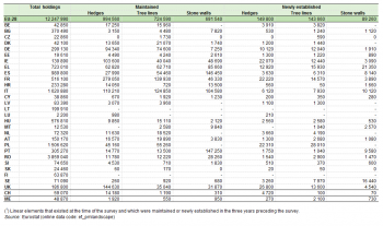
Landscape features are found on many of the farms in the European Union (EU) (see Table 1):
- almost one million agricultural holdings in the EU-28 maintained hedges (about one in every twelve holdings) in the three years prior to the 2010 survey;
- almost three quarters of a million holdings maintained tree lines;
- a little over two thirds of a million holdings maintained stone walls;
- about 150 000 holdings established new hedges, a similar number planted new tree lines, and about 90 000 holdings built new stone walls.
Note that agricultural holdings can both maintain and establish multiple landscape features.
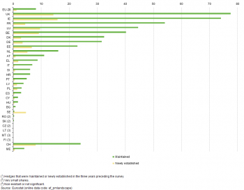
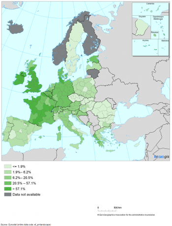
Hedges are a common feature of the British and Irish landscape, where enclosing common land for raising sheep became a feature of the 18th and 19th century enclosure movement. About three quarters of all agricultural holdings in the United Kingdom (77.4 %) and Ireland (74.1 %) maintained hedges in the three years prior to the 2010 survey, with about one in every six or seven holdings also involved in establishing new hedges; these were by far the highest proportions across the EU Member States (see Figure 1). By contrast, hedge maintenance was not an activity carried out on farms in the Czech Republic, Lithuania, Malta, Romania, Slovakia, Finland or Sweden. This disparity within the EU is underlined at a regional level (principally for NUTS level 2 regions); in England, Wales, Northern Ireland, Ireland, the south of Belgium, and the west and centre of France a clear majority (at least 57.1 %) of holdings maintained hedges (see Map 5.1). These were more or less the same NUTS level 2 regions where new hedges were most likely to have been established in the three years prior to the 2010 survey (see Map 5.2).
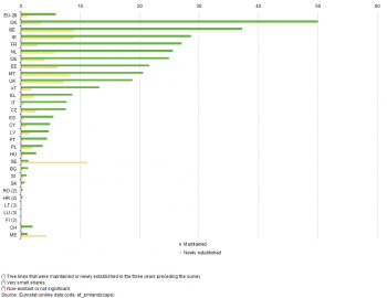
One half (50.0 %) of the agricultural holdings in Denmark maintained tree lines (such as tree avenues or alleys) in the three years prior to the 2010 survey, the highest proportion among the EU Member States and much higher than the 5.9 % average across the EU-28 as a whole (see Figure 2). Relatively high proportions of holdings in Belgium, Ireland, France, the Netherlands and Germany (between 25 % and 38 %) maintained tree lines. By contrast, tree lines were not a landscape feature typical of a number of Member States such as Croatia, Lithuania, Luxembourg, Romania and Finland.
Dry stone walls are a widespread landscape feature of Malta (nearly four in every five agricultural holdings maintained stone walls in the three years prior to the 2010 survey). These stone walls may prevent soil erosion and they were also used to parcel land being bequeathed by farmers to their children; these characteristics are also a feature of other countries too. Almost half of the holdings in Portugal maintained stone walls with about one third of holdings in Ireland doing likewise (see Figure 3).
The use of landscape features in Sweden appears to be on the rise: hedges were established on 4.6 % of all agricultural holdings in 2010, tree lines planted on 11.2 % of holdings and stone walls were built on 23.1 % of holdings. These developments are being supported by a specific measure financed under the rural development programme.
Data sources and availability
The data on landscape features that have been used in this publication were collected for the first time in 2010 as part of the survey on agricultural production methods (SAPM). This survey was carried out together with the farm structure survey (FSS) as a census in some countries, whereas in other countries the SAPM survey was carried out as a sample survey and data were linked to data from the FSS census at the level of the individual holding to enable cross comparisons of characteristics collected in SAPM and characteristics collected in the FSS census.
The SAPM was conducted consistently throughout the EU with a common methodology providing therefore comparable and representative statistics across countries, at regional levels down to NUTS level 2 (NUTS level 1 in Germany).
Data on linear elements were collected regardless of whether the holding received payments for the maintenance or establishment of these elements. Data were collected in the form of yes/no questions; data are therefore not available on the number of linear elements or the quality of these elements. The survey requested information pertaining to existing linear elements which were maintained in the three years prior to the survey as well as newly established linear elements that were created in the three years prior to the survey.
Context
Through its resource use, agriculture changes rural landscapes and contributes to resource depletion and degradation. Via substance emissions into the wider environment, agriculture may contribute to a complex series of ecological impacts, including human health effects, biodiversity loss and climate change. Policy responses to environmental concerns have included the introduction of: resource use constraints and limits; emission and concentration limits; best available techniques, methods and practices. Nature conservation policies have also been implemented that set various agricultural constraints.
Agri-environmental indicators can be used to analyse, over time, the effects of agriculture on the environment and the interaction between the two, as well as the effectiveness and efficiency of agricultural and environmental policy measures. A Communication from the European Commission to the Council and European Parliament titled, ‘The development of agri-environmental indicators for monitoring the integration of environmental concerns into the Common Agricultural Policy’ (COM(2006) 508) identified 28 agri-environmental indicators (AEIs) to help with this assessment; Eurostat coordinates the work within the EEA on the development of these indicators.
As farming systems became more intensive and mechanised, the margins of fields were often grubbed up or destroyed to allow more efficient use of the land by ever larger and more specialised machines. However, these landscape features have become recognised as an increasingly important resource for the environment. Indeed, under the current Common Agricultural Policy (CAP), in order to receive a full decoupled direct payment, a farmer has to comply with good agricultural and environmental condition (GAEC) standards. The objective of these standards is to ensure that all agricultural land, especially land which is no longer used for production purposes and permanent pasture, is maintained in good condition. Under Council Regulation (EC) 73/2009, the maintenance of landscape features, including, where appropriate, hedges, ponds, ditches, trees in line, in group or isolated, and field margins is specified as a compulsory GAEC standard, whereby farmers should ensure minimum levels of maintenance and avoid the deterioration of habitats.
See also
- Land cover, land use and landscape
- Landscape structure indicators from LUCAS
- Survey on agricultural production methods (background article)
Further Eurostat information
Publications
- Agriculture, forestry and fishery statistics — 2013 edition (Pocketbook)
- Diversified landscape structure in the EU Member States - Statistics in focus 21/2011
Database
- Agriculture (agri), see:
- Farm structure (ef)
- Farm structure 2010 (ef_2010)
- Survey on agricultural production methods (SAPM, 2010) (ef_pm)
- Landscape features: number of farms and areas by agricultural size (UAA), economic size of farm (SO in euros) and NUTS 2 regions (ef_pmlandscape)
- Survey on agricultural production methods (SAPM, 2010) (ef_pm)
- Farm structure 2010 (ef_2010)
Dedicated sections
Methodology / Metadata
- Farm structure (ESMS metadata file - ef_esms)
Source data for tables, figures and maps (MS Excel)
Other information
- Commission Communication COM(2006) 508 - Development of agri-environmental indicators for monitoring the integration of environmental concerns into the common agricultural policy
- Commission Staff working document accompanying COM(2006)508 final
- Corresponding IRENA Fact sheet:
- Regulation 1166/2008 of 19 November 2008 on farm structure surveys and the survey on agricultural production methods (legal text)
- Regulation 1200/2009 of 30 November 2009 implementing Regulation 1166/2008 on farm structure surveys and the survey on agricultural production methods, as regards livestock unit coefficients and definitions of the characteristics (legal text)