Applying the degree of urbanisation manual - Tools and training
10. Tools and training
This article forms part of an online methodological manual, Applying the Degree of Urbanisation – A methodological manual to define cities, towns and rural areas for international comparisons: 2021 edition.
The degree of urbanisation classification is a geospatial concept that can be implemented in geographic information systems (GIS) – computer systems designed to analyse spatial data. However, this requires adequate expertise to operate the GIS in an appropriate way and the availability of the necessary population and, optionally, built-up density grids. There is a strong demand for ready-to-use tools that facilitate the application of the degree of urbanisation classification as well as for capacity building that assures a conscious implementation of the methodology on which it is based.
This chapter describes tools that are currently available and training materials that have been produced by the European Commission’s Joint Research Centre (JRC) Global Human Settlement Layer (GHSL) project to support the development of a harmonised global definition of cities and settlements.
Full article
10.1 Tools
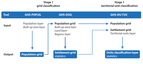
The tools described in this subchapter address three production steps that are described in the previous chapters. The first step is the construction of a regular-spaced population grid from given geospatial population data in the form of points or polygons (see Chapter 5). The second step is the application of the methodology to a given population grid and additional optional layers (see Chapter 6 and Chapter 7). Finally, in the last step, the derived grid cell classification is used to classify small spatial units into cities, towns and semi dense areas, or rural areas (see also Chapter 6 and Chapter 7). Figure 10.1 displays the workflow to operationalise the tools that have been produced within the framework of the GHSL.
The tools described below are open and available free-of-charge from the GHSL tools website. They require the installation of MATLAB Runtime (available from MathWorks), which is a standalone set of shared libraries that enable the execution of compiled MATLAB applications. The tools are also available as an ArcGIS toolbox, compatible with ArcMap 10.6. The tools were developed to run on standard computers. They all run on Windows 10 operating systems with any processor and require at least 16GB RAM. It is important to note that more memory is required for processing larger data sets. More details can be found in the corresponding user manuals (see below for more information on specific user guides).
10.1.1 Construction of a population grid (population to grid tool – GHS-POP2G)
A population grid is the key input to produce the grid cell classification that is necessary in order to compile data by degree of urbanisation. A population grid is obtained by re-allocating population counts from points and/or polygons to gridded surfaces of regular and standardised grid cells or pixels. The population grid is produced through geospatial and geo-statistical processing of geo-coded population data (as available).
Population grids can be produced in alternative ways depending on the type of data available. One process is that of aggregation. The aggregation approach is generally used when micro-census source data have higher spatial detail (resolution) than the selected cell size of the population grid. A point-based micro-census is usually conducted at the building or census block level, and this high level of spatial detail should be the only one for which this aggregation technique should be deployed. Population grids are more generally produced through disaggregation of population counts attached to small spatial units – statistical areas or administrative units. The GHS population grid layers (GHS-POP) are produced through disaggregation (the population input is the Gridded Population of the World v4.10 (CIESIN (2018)). The disaggregation is driven by the density of built-up areas as a proxy for the location of the resident population.
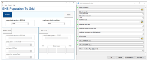
To support the uptake of this methodology, the GHSL project has developed a population to grid tool – GHS-POP2G (version 2). This is a flexible tool to produce geospatial population grids in GeoTIFF format from census data. It operationalises the workflow developed for the production of the GHS-POP. GHS-POP2G offers the possibility to create population grids at 50 m, 100 m, 250 m and 1 km spatial resolutions, handling census data stored as point or polygon vector data (the latter case requires an additional covariate as input for dasymetric disaggregation); it is available as standalone software or as an ArcGIS toolbox (see Figure 10.2). The principal purpose of the tool is to produce a population grid that may be used as an input for the degree of urbanisation grid tool (GHS-DUG) which has also been produced within the GHSL framework. However, potential uses of the tool and population grids extend far beyond this principal application. The GHS-POP2G user manual (Maffenini et al. (2020a)) explains all of the functionalities and requirements to run the tool.
10.1.2 Classifying grid cells (degree of urbanisation grid tool – GHS-DUG)
The degree of urbanisation grid tool – GHS-DUG (version 4) is an information system to produce geospatial grids for degree of urbanisation classes and related statistics.
GHS-DUG 4 is designed as a scalable tool allowing the application of methodology to available population grids or to data made available in the GHSL Data Package 2019 (Florczyk et al. (2019)).
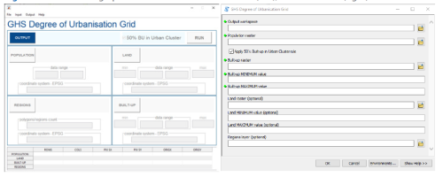
The GHS-DUG implements the workflow developed for the production of the GHS-SMOD. It produces a grid cell classification for the entire area of interest in GeoTiff format at 1 km spatial resolution according to both level 1 and level 2 of the degree of urbanisation classification. GHS-DUG requires a population grid (at 1 km resolution) and optionally a built-up surface and land fraction layers. When a shapefile delimiting territorial units is provided, the tool compiles statistics by degree of urbanisation class. The principal purpose of the tool is the production of a classification of grid cells by degree of urbanisation. The GHS-DUG grid output is used to operationalise stage 2 of the methodology (the classification of small spatial units) and is used as an input for the degree of urbanisation territorial unit classifier tool (GHS-DU-TUC) also produced within the GHSL framework (see Subchapter 10.1.3). The GHS-DUG user manual (Maffenini et al. (2020b)) explains all of the functionalities and requirements to run the tool. Figure 10.3 shows the graphical interface of the GHS-DUG tool both for the standalone tool and for the ArcGIS toolbox.
10.1.3 Classifying small spatial units (degree of urbanisation territorial unit classifier tool – GHS-DU-TUC)
The methodology classifies the entire territory of a country along the urban-rural continuum into regularly spaced grid cells. However, often it is required to classify small spatial units, for example a commune or municipality. The GHS-DU-TUC tool implements this transition from the grid cell classification to the classification of small spatial units based on the type of grid cells in which the majority of their population resides.
The degree of urbanisation territorial unit classifier tool – GHS-DU-TUC (version 1.0) is designed as an operational tool that classifies small spatial units based on the grid cell classification already derived using the GHS-DUG tool. It requires the following inputs: a classification of grid cells, a population grid and a geospatial layer containing the small spatial units. The input population grid must be the one used for the production of the grid cell classification through the GHS-DUG tool. GHS-DU-TUC produces a geospatial layer in vector format (a shapefile) that contains the classification of small spatial units according to levels 1 and 2 of the degree of urbanisation classification, plus a statistical table with the classification of the small spatial (territorial) units and their population counts. The GHS-DU-TUC user manual (Maffenini et al. (2020c)) explains all of the functionalities and requirements to run the tool. Figure 10.4 shows the graphical interface of the GHS-DU-TUC tool both for the standalone tool and for the ArcGIS toolbox.
10.2 Training
The tools described in the previous subchapter are distributed with detailed manuals that encourage autonomous use (see External links in the Direct access to section at the end of this article for further details). Nevertheless, additional training materials or training courses are available to expedite the correct selection and application of the different options. In preparation for the 51st session of the UN Statistical Commission, partner organisations supported a range of countries in different ways to increase their capacity to understand and implement the methodology.
UN-Habitat together with the European Commission organised seven regional workshops between 2018 and 2019 to present the methodology underlying the degree of urbanisation classification and discuss how this could be improved and applied to national data. A total of 85 countries participated in these workshops (see Figure 10.5).
As a follow-up to the workshops, the JRC conducted dedicated training in the United Arab Emirates at the request of the Federal Competitiveness and Statistical Authority, and at the UN-Habitat Headquarters in Kenya for UN-Habitat staff. Further events and a comprehensive training package are under preparation.
The objective of training courses is to provide an overview of the data, methods and tools developed by the GHSL project, to provide examples of how data and tools can be used to apply the methodology, and which applications it can support. The course includes presentations and practical exercises. The presentations are targeted at a general audience with a background in regional and urban development and to those working for national statistical authorities; the practical exercises require some basic knowledge in GIS and spreadsheets and the installation of dedicated software prior to the exercise (see Subchapter 10.1 for more details of the specific requirements).
Training courses address four broad themes through presentations:
- The first module addresses the need for a global definition of urban and rural areas for international statistical comparisons.
- The second module explains the GHSL datasets: the built-up area spatial grids (GHS-BUILT), the population spatial grids (GHS-POP), the settlement model spatial grid (GHS-MOD) and the urban centre database (GHS-UCDB).
- The third module explains the JRC’s solution to operationalise the degree of urbanisation classification into a settlement classification grid and into the classification of small spatial units by degree of urbanisation for urban and rural areas.
- The fourth module shows examples of GHSL data applications, to support policymaking with new findings on human settlements.
Those taking part in the practical training exercises can expect to learn the following skills:
- Construction of a population grid with the population to grid tool (GHS-POP2G).
- Classification of grid cells with the degree of urbanisation grid tool (GHS-DUG).
- Classification of small spatial units by degree of urbanisation with the degree of urbanisation territorial unit classifier tool (GHS-DU-TUC).
- Disaggregation of statistics and indicators according to the degree of urbanisation classification.
- Estimation of sustainable development goal (SDG) 11.3.1 for urban areas (LUE tool).
The production of stand-alone online courses and webinars is under preparation.
10.3 Online resources for the degree of urbanisation classification
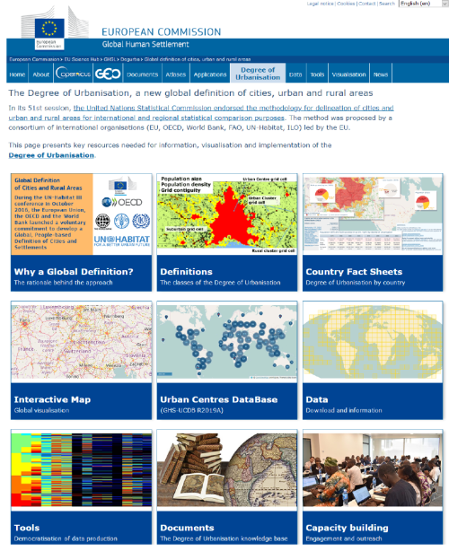
In order to support the discussions with interested countries and stakeholders, the JRC has also created a dedicated web presence for the degree of urbanisation classification. The homepage contains everything that is needed to understand and implement the degree of urbanisation classification (see Figure 10.6).
The different sections include:
- An introduction to the methodology: why there is a need for a global, people-based definition of cities and urban and rural areas.
- A summary of the methodology.
- Country fact sheets summarise the application of methodology based on data from the GHSL and publicly available country borders.
- Interactive maps and the application of the methodology in the Urban Centres Database.
- A data section that provides open data for the global grids of the GHSL dataset including built-up area grids, population grids and settlement classification grids (GHS-SMOD layers).
- The tools section with links to the available set of tools for implementing the methodology.
- A list of essential documents.
- A section summarising materials and initiatives for capacity building.
Direct access to
- Center for International Earth Science Information Network (CIESIN), Columbia University (2018), Documentation for the Gridded Population of the World, Version 4 (GPWv4), Revision 11 Data Sets, NASA Socioeconomic Data and Applications Center (SEDAC), Palisades, NY.
- Florczyk, A., C. Corbane, D. Ehrlich, S. Freire, T. Kemper, L. Maffenini, M. Melchiorri, M. Pesaresi, P. Politis, M. Schiavina, F. Sabo, and L. Zanchetta (2019), GHSL Data Package 2019, JRC 117104, EUR 29788 EN, Publications Office of the European Union, Luxembourg.
- Maffenini, L., M. Schiavina, S. Freire, M. Melchiorri, M. Pesaresi and T. Kemper (2020a), GHS-POP2G User Guide, JRC 121485, Publications Office of the European Union, Luxembourg.
- Maffenini, L., M. Schiavina, M. Melchiorri, M. Pesaresi, and T. Kemper (2020b), GHS-DUG User Guide, JRC 121484, Publications Office of the European Union, Luxembourg.
- Maffenini, L., M. Schiavina, M. Melchiorri, M. Pesaresi, and T. Kemper (2020c), GHS-DU-TUC User Guide, JRC 121486, Publications Office of the European Union, Luxembourg.


