
Satellite data can help protect bluefin tuna
A new model developed by scientists of the European Commission's Joint Research Centre (JRC) allows the potential presence of bluefin tuna to be tracked through daily updated maps, helping to protect endangered stocks and fight illegal fishing.
European Commissioner Maria Damanaki, said "Responsible fisheries management decisions that ensure the sustainable exploitation of fisheries resources and the availability of fish for future generations worldwide rely on good science. New findings, like the JRC's new model, will help us greatly in our efforts to protect bluefin tuna and fight illegal fishing practices."
Read more and comment on Commissioner Damanaki's blog: "Bluefin tuna: a matter of responsibility"
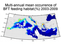
The model, based on satellite remote sensing data, provides for the first time an overall view of the preferred bluefin tuna habitats in the Mediterranean Sea, as well as their changes over time. Satellite-based habitat mapping can help identify more precisely areas to be inspected or to be closed for fisheries and it can also help refine estimates of fish stocks, thus contributing to a more effective fisheries management.
Despite the measures taken by the International Commission for the Conservation of Atlantic Tunas (ICCAT), there is a need to increase the knowledge about spawning grounds for exploring additional management measures.
